Roughly half of all residential floodplain development in U.S. was built in Florida

A nationwide analysis of community-level floodplain development found that over two-million acres of floodplain were developed over the past two decades across the United States, with roughly half of all new floodplain housing built in Florida.
These findings from scientists at the University of Miami Rosenstiel School of Marine, Atmospheric, and Earth Science provide new information on patterns of floodplain development that pose a potential risk to people and communities in regions like the Southeastern U.S. that are especially prone to flooding.
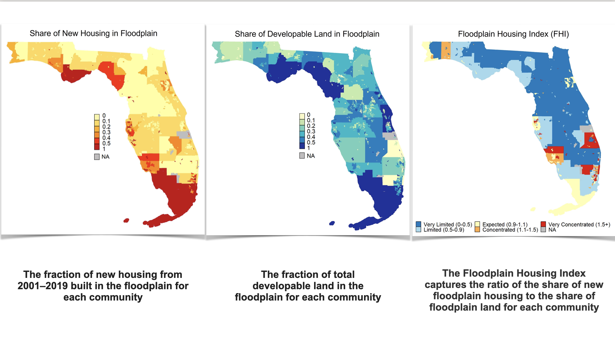
In the new study, researchers combined geospatial land use, impervious surface, and housing data with information from digitized regulatory floodplain maps to measure new floodplain development for communities across the U.S. The analysis, published in the journal Earth’s Future, found that over 840,000 new residential properties were built in the floodplain across the U.S. with about 398,000 of those built in Florida, which represents 21 percent of all new housing built in the state and the highest total of any U.S. state.
“Given the size of floodplains and amount of new overall housing growth, those figures are actually much less than we would expect,” said the study’s lead author Armen Agopian, a Ph.D. student in the Abess graduate program at the Rosenstiel School.
The researchers note that if new housing was distributed proportionally to the share of floodplain land in Florida, they would expect to see 40% of new housing built in the floodplain.
They also found that 74 percent of communities across the United States have limited new development in floodplains, and 87 percent have limited new housing in floodplains through local government regulations and practices. The analysis also found that coastal communities are more likely to concentrate new development and housing in floodplains as compared to inland communities.

The study revealed that communities that participate in FEMA’s Community Rating System, a voluntary incentive program that rewards communities that adopt certain practices with discounted flood insurance rates, were found to have a higher likelihood of floodplain development.
“Communities with a flood problem enroll in the program, but participating alone isn’t enough to support safer development patterns. Instead, communities need both to participate and to improve their floodplain management practices—those are the ones that start to limit floodplain development,” said Agopian.
Development in flood-prone areas is a major driver of increases in flood-related damage, increasing both the likelihood that a flood will impact people and infrastructure and the severity of harm when it does.
This study is the first comprehensive dataset measuring floodplain development outcomes, community by community, nationwide. To date, most research on flood damage and actions has focused on the places that have experienced big floods with homes destroyed or lives lost.
“What we find is that many communities around the nation have taken smart action early on, avoiding development in their floodplains from the start. There’s a lot we can learn from these communities that are often with little fanfare avoiding flood problems from the start,” said senior author of the study Katharine Mach, professor and chair of the Rosenstiel School Department of Environmental Science and Policy.
