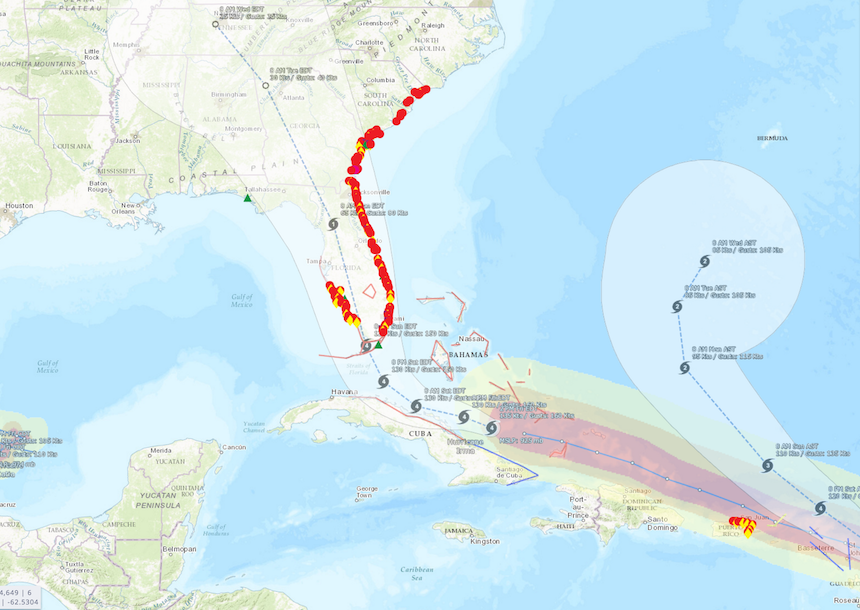
Large and powerful Hurricane Irma is likely to cause significant erosion along U.S. east coast beaches from Florida through South Carolina, according to a new projection from the U.S. Geological Survey. Strong waves and storm surge are likely to erode all sandy beaches in the three states, overtop sand dunes over three-quarters of the coast, and, in some areas, inundate areas behind the dunes. These coastal impacts are based on the National Hurricane Center’s 8 September storm track forecast. Actual impacts may be very different if the track moves to the west and affects the Gulf coast.
USGS says that water levels three to four meters, or 10 to 12 feet, above normal tide levels are likely for open coast shorelines along Florida’s Atlantic coast if Irma continues to track along the east coast, according to Thursday’s forecast from the USGS Coastal Change Hazards Group based in St. Petersburg, Florida.
“Our models are showing that the entire coastline of Florida is likely to experience extensive dune erosion,” said USGS research oceanographer Hilary Stockdon, the lead developer of the group’s coastal change forecasting tools. “That’s because Hurricane Irma is large and powerful. But it’s also worth noting that many of these beaches took a beating during Hurricane Matthew last year. So dunes that were eroded during Matthew may not be there to protect some coastal communities during Irma.”
Coastal change predictions for North Carolina will become available as the storm moves closer to that part of the coast, Stockdon said.
The USGS’ coastal change forecasting model uses the National Hurricane Center’s storm surge predictions and wave forecast models from the National Oceanic and Atmospheric Administration. The USGS model adds information about the beach slope, dune height, sea floor topography and other features to predict how high waves and surge will move up the beach and whether the protective dunes will be overtopped.
The projected results are based on the assumption that the storm surge will strike at high tide, and are intended as a worst-case scenario, Stockdon said. They cover only sandy beaches and do not make any estimates of storm effects along stretches of the coast lined by seawalls, marshes or mangroves.
Beach erosion is only the first level of damage a major storm can cause. Waves and surge can overwash the top of the dune, depositing sand inland and causing significant changes to the landscape. Inundation, the most severe impact, occurs when beaches and dunes are completely and continuously submerged by the surge.
A map of these estimates is posted on the USGS’s Coastal Change Hazards Portal. Emergency managers can use the forecast to help identify locations where coastal impacts might be the most severe – for example, where roads may become impassable because of sand, or where storm surge and waves may put some roads underwater.
An experimental new forecasting tool, called the Total Water Level and Coastal Change Forecast Viewer, offers projections of the timing and the amplitude of storm-induced total water levels – both waves and surge – for specific places along the Florida Atlantic coast from Miami to a point near Palm Bay, and for the state’s Gulf coast from the St. Petersburg area to Marco Island. The information, which is provided at 3-hour intervals for a 6 day period, is not intended as a substitute for the National Hurricane Center’s storm surge warnings, Stockdon said.
“This is a serious storm,” Stockdon said. “Everyone in Florida should listen to their local emergency management teams and evacuate when they say ‘Go.’”
As Hurricane Irma moves closer to the U.S. mainland, the coastal change projections are subject to change. The most recent projections are available on the National Assessment of Storm-Induced Coastal Change Hazards – Hurricane Irma page.
